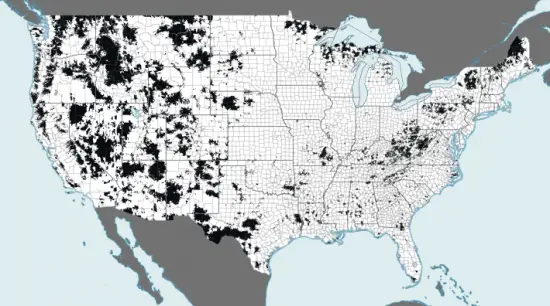
For those of us from large metropolitan areas, we often take our 3G, if not 4G, coverage for granted, but the number of areas in the United States not serviced by a high-speed mobile network may surprise you. Each splotch of black on the above map represents an area of the US population that was not receiving at least 3G coverage as of January 2012. The splotches become bigger and bigger as you move out west.
The interactive map (embedded below) allows you to zoom in and get a better idea of just how many citizens are affected. The numbers are usually rather low, ranging from a handful of people up to a few thousand, but they add up. Most of these areas are less densely populated with wide gaps in infrastructure, but some can be found just miles from the biggest cities in the country, including New York.
The bigger issue is that mobile providers continue to upgrade their networks in the big markets while ignoring the needs of those stuck with 2G coverage, a problem the Mobility Fund is hoping to call attention to through their startling look at US mobile coverage. While we sure do love our 4G connection speeds, other shouldn’t have to miss out based on where they live.
[via WinSource | Thanks, Samantha!]


i have been stuck on 2g speeds the past 4 years on tmobile.. the town next to me got 4g.. yet our town still can’t even get 3g. no black spot on the map tho.
Tmobile is a metro carrier mostly, they won’t get you 3g in a rural area. Doesn’t mean 3g isn’t on another carrier. Burlington VT for instance has 3g on sprint, verizon, and at&t, but only 2g on tmobile with no native service from tmobile in the whole state (tmobile owns no 802 area codes which cover the state). So yeah, if there’s no black spot where you are, you can be sure some carrier, most likely verizon or at&t, has 3g coverage where you are.
A lot of those “blotches out west” are in the mountain ranges. They pretty much follow both the Rocky Mountains and the Sierra Nevadas, as well as a few other minor ranges. And most of the area not covered in Nevada is uninhabited.
Most of Arizona is reservations or uninhabited. The Oregon part is probably mostly trees in that area. I imagine 50 foot pine trees would make signal suffer pretty badly.
You’re completely right. I live in a small Arizona town for about 2 months out of the year and it borders a reservation. There are NO towers on that land, but thankfully, Verizon was smart enough to put their towers on the higher peaks. Also, in southern Arizona, there (other than Tucson) are only a handful of towns that are bigger than 5000 people, so I don’t think cell companies want to expand in those areas.
I’m blanketed by white on the map, but I’m on a 1x connection when I go off WiFi. What gives, Sprint?
this map is for 3g on ANY carrier. i’m sure verizion or at&t has 3g where you are.
Wireless providers should not be forced to lose money on areas with little or no customer base to support the infrastructure costs. A cell phone is a privilege not a right despite what our corrupt politicians might think.
That was also said of electricity, water, broadband, roads, etc, out in rural areas. Eventually it becomes a necessity and is in our common interest to help build out (with “evil” tax credit help).
By that logic no one should have a phone at all. It was the same situation when land lines were invented. As people move from land lines to cellular as their primary phone type infrastructure will have to expand, even to lowly populate areas. Sure, there was a point when the land line was a privilege also, but as the song says ” times…..they keep on changing”
yea think of bodies of water, large trees, mountains, or just areas that are persevered for wildlife and stuff like that.
and “just miles from new york city ” try hundreds of miles.
compare this map to google maps.
instead of saying “yea now i got something to write about”
think “ok let me actually do research before i post something thats completely stupid”
the animals that dont have 3g are probably happy there getting some recognition tho.
dude shut up. Plenty of people live in these rural areas. Stop being an ignorant douche
damn you’re rude
Actually, the uncovered area in sussex NJ which the map shows, is only 56 miles from NYC. Given that it is officially a part of the New York Metropolitan area which goes out even farther than that, meaning people commute from there to NYC each and every day for work, it is kind of sad that there is an underserved area. Luckily the population that is underserved is only 38 according to the FCC, so it is likely a rural part outside of the town, but still a space like that shouldn’t exist in the metro area of any major city, let alone the biggest in the nation.
Yeah, this map is very misleading. There are major state highways and interstates in Texas and New Mexico that have no or just 1x coverage by Verizon. And why does everyone still talk about population covered? I can take my phone outside the house, how about you?
I really think that this map is showing a correlation between coverage and terrain rather than coverage and population….
If you’ll notice, the white (coverage areas) spots are at their most strong in the midwest (flat and hilly, but not highly populated) yet splotchy in places like PA, OH, new england states, and southwest like TX, AZ and CA (hilly more mountainous areas)
What I’m saying is that the strongest coverage areas are flat with fewer people and the lower coverage areas are more hilly but with more people.
So my take is not that carriers are ignoring places with less infrastructure/population, etc….. but that they are either hesitant or unable to put towers that adequately cover in the mountains of our great nation.
Wow. Look at the Upper Peninsula of Michigan. It looks like a rabbit with mange! And I might be moving there. Crap.
Its really spotty up there man, hate to tell you…
Most of the black areas are in the mountains. The Rockies out west, the Ozarks and Ouachitas of Arkansas, and the Appalachians out East. This is not at all surprising.