Info on more than 1 million transit stops now in Google Maps, update coming soon
Google has made some exciting announcements regarding Google Maps. For starters, they’ve revealed that the service now has information for over 1 million transit stops around the world. Yay!
But with that great news also comes word of an impending update for the Google Maps application that everyone will want to get their hands on.

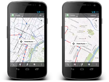
They’ve made changes to transit line layers so you can differentiate between train, bus, trams, or subways. This’ll help make sure users aren’t looking at the wrong lines for areas that overlap. They’ve also made the following changes:
In addition to these new transit features, we’ve updated region highlighting, My Places and Location History displays in Google Maps for Android:
- Now, whenever you search for a city or postal code, the borders of that region are highlighted.
- Under My Places you’ll notice we’ve added new tabs, which will help you access all your information from a single place; from your saved maps for use offline to your starred places and Custom Maps created on your desktop.
- If you enable Location History, you’ll be able to browse the places you’ve been on a daily basis with an updated Location History dashboard.
Unfortunately, the app is not yet in the Google Play Store but Google says it will definitely be out sometime today. We’ll be looking out for version 6.10 once it does arrive. Head to Google’s lat long blog for more information.