Real-time New York City subway service updates now available in Google Maps
![]()
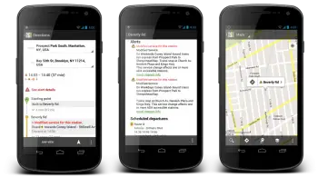
Google has updated Google Maps to include real-time service updates for New York City subway users. When clicking on one of 468 subway stations Google Maps will show any alert that may be causing a delay or stoppage in service.
Google will also alter directions based on service interruptions to ensure you’re not being thrown from the pan into the fire should you happen to encounter more than one service interruption on your route.
It is a pretty big feat for Google, but they finally got it done for the busiest city in the nation and one of the biggest in the world. Grab Google Maps from the Google Play Store. [via Google]