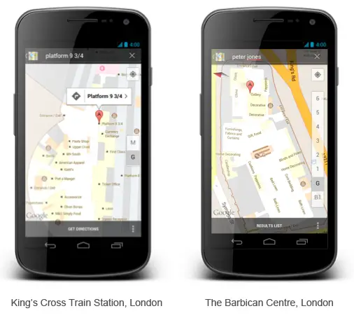
Google has announced that users in the UK can now get indoor maps on their Android devices. The update to Google Maps allows users to get a map of the inside of several venues.
You can get directions to a certain point within the building, and it’ll even recognize which floor you’re on. Google’s come out of the UK starting gate with 40 different venues to start, and as you can imagine a lot of those venues are train stations, department stores, and airports.
Google’s committed to bringing more over time, and they’ll even accept floor plans from store owners who want their store included in the future.
You can get to the indoor map of a venue by simply zooming in on its location. Find more information at the Google Lat Long (fancy way of saying Maps) blog here.


Though I’d hardly use it, all I can say is: NETHERLANDS next please! And to the rest of the world while your at it :D
Well I’d say they need to improve the UK one first. 40 buildings out of 244,000 squared km, not much
In theory this is a very useful feature… But from my past experience in large cities (only downtown Chicago) my GPS wouldn’t even come close to being accurate enough to point me to the correct platform at the train station. Maybe it’s because t-mobile sucks in Chicago, or because Union Station doesn’t allow me to get good service? Who knows
The GPS (Samsung Galaxy S III also uses Glonass) is a network of 24 satellites. If you cannot see the sky ie when you’re in a building then you won’t have an accurate position. T-Mobile only provides the data for the maps to load. It’s also possible that anything underground or with thick walls blocks data transfer. The idea is for you to work out where you are from the map
Love how Platform 9 3/4 is on the map