When I watched the below videos about a new Android App called Route 66, I immediately wondered what mapping software was used to create them. The second video looks almost identical to the new version of Google Maps and I figured it simply leveraged the Maps API, but as it turns out they’re powered by TomTom. Have a look:
I suppose it’s possible the first video featuring the navigation shows TomTom powered maps while the simpler location maps are Google Maps based – we’ll have to get clarification on that. But let’s talk a little bit about the software in general.
TomTom has a pretty loyal following and this partnership between Route 66 and TomTom should make a lot of TomTom lovers happy. The app looks incredibly polished overall, and along with Mapquest should instantly become a pretty solid Google Maps & Nav competitor. They’ve both got an uphill battle with Google, but this looks like a valiant effort.
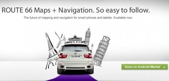
I’m not too excited about this “Follow Me” feature though, which I thought was a good idea but is in reality almost pointless. What was the missing link?
I thought that “Follow Me” meant you would “share” live location data between the two phones so that while navigating to your address you could track where the other person is, or even get constantly updated navigation directions to the other person’s current whereabouts, essentially allowing you to follow them even if you can’t see them. That’s not what it is at all.
“Follow Me” just puts a fake animation of a car on the screen in navigate mode so it gives you the impression you’re following another car instead of looking at an open road. It also uses your phone’s camera to show a live view of the street instead of a fake map view. To me this falls flat for two main reasons:
- I don’t want to see the “real” street, I want a graphical version of the street that is more clear and defined and not dependent on elements like outdoor lighting and weather.
- Get the car out of my way! It’s a waste of space and kind of annoying… rather than giving the feeling of following someone it makes me feel like I’m stuck in traffic.
To be perfectly honest, I don’t see myself switching from Google Maps/Nav but Route 66 and Mapquest have some intriguing options that are making me think I’d at least like to test them out. I’m pulling for a Google Maps competitor to gain popularity because, as I always argue, competition is good for business and consumers alike.


I think i see where they are going with Follow Me feature.. If you think about it, the augment reality with visual map over laying on the camera will get confusing when road splits up and has crazy turns coming up. Having a car as a director telling you exactly when to make the turns i think will help the driver make the accurate turn. If you check the link below its another augment reality GPS app showing in action, but watch the video when turns gets crazy its hard to tell when to make the turn. Having a car or some kinda 2nd indication of making turn is good idea!
http://www.youtube.com/watch?v=nFJRGab4oKQ&NR=1&feature=fvwp
It seems like having a fake car to follow could be dangerously distracting. Could your concentration be diverted from the real road in your windshield while you are watching this display? Especially bad if the real road includes a real car ahead slamming on it’s brakes!
If the voice directions are comprehensive then you really should not need the display at all.
I did the beta of a nav app that used the camera, and the biggest problem I found was that my mount blocked my phones camera. Once I modified to mount to allow my camera to see, I kept having to make minor adjustments to the phone/mount to get the real road and virtual road to match. Also, when I finally got the camera pointed the right way to work the phone was not in an optimal position to view while driving. In the end it sounds a lot better than it works in reality.
is it free? Thats the only way it will compete with google maps on my EVO.
Another half baked effort to hold on to market share before Android and Google Maps takes over.
So if I’m reading that right, maps are downloadable which is nice, but you need a subscription for turn-by-turn directions. I think I’ll still with Google for now.