The once-European exclusive GPS app – Navigon – has made its way to the United States marketplaces of Yankee Android users everywhere. It challenges current offerings from the likes of Telenav and CoPilot, who’ve been enjoying a nice share of the North American mobile GPS market for a long while.
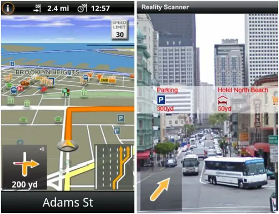
Some of Navigon’s compelling features include a “Reality Scanner,” which is their implementation of augmented reality while utilizing the turn-by-turn to get to quickly spot the area’s most popular checkpoints, lane-level navigation to ensure you’re turning at the the right intersection or freeway exist, and even a database of known stop lights that have speeding cameras installed.
All of this and more is normally available for $59.99 (we know), but they’re kicking things off with a two-week sale to grab it up for $39.99. It’s not the most affordable package in the world, but it does sound like they offer some features you just won’t find in other apps. Initial download is 30 MB with an additional 1.5 needing to be reserved on your microSD card for the storage of maps and voice data. It’s available for Android 1.5 and higher. Read on for full press details.
NAVIGON Launches On-Board Navigation App for Android Smartphones
Provides Premium, All Inclusive Experience with On-Board Map Material, Industry First Reality Scanner and Traffic Live
Hamburg, Germany October 27, 2010-NAVIGON AG, a leading provider of mobile on-board navigation, today announced the release of the US version of its award winning MobileNavigator for the Android platform. The first on-board navigation app of a major navigation company to launch on the Android platform, MobileNavigator brings premium navigation to the growing Android user base. Among many signature functions, the app includes the industry-first feature Reality Scanner that identifies points of interest by showing them in a live camera view. MobileNavigator is available now from the Android Market and includes Traffic Live and without an additional cost.
MobileNavigator brings first-class developments in GPS navigation technology and real-time travel information to the Android platform. “For almost two decades NAVIGON brings preeminent navigation technology; this long standing experience enables us to deliver sophisticated navigation solutions that transform smartphones into navigation solutions comparable to standalone devices,” said Gerhard Mayr, NAVIGON vice-president worldwide mobile phones and new markets. “Other than free navigation apps for the Android platform, NAVIGON’s app provides on-board premium maps and driving related features that go beyond providing simple directions, helping to make driving a more relaxed experience.”
Reality Scanner is an industry first feature for the Android platform. Utilizing the phone’s build-in camera, positioning, and compass components together with NAVIGON’S extensive POI database to project POI (points of interest) icons directly on the camera’s image. Users can point the device and instantly identify POIs in or around the location. Other premium features include, Reality View Pro, displaying photo-realistic 3D views of actual road, highway/interstate, signs and exits, and lane guide markers for easy driving decisions. Traffic Live uses real-time data from over a million drivers to route around traffic. NAVIGON MyRoutes analyzes driving habits, patterns, location, time/day and provides up to three routes clearly displayed in-map with ETA, distance and driving times for each (a comprehensive list of features is below). The NAVIGON Red Light Cameras feature provides drivers an advanced visual warning for most red light and speed cameras.
MobileNavigator relies on the devices’ GPS receiver as well as the pre-loaded NAVTEQ® maps, providing full function navigation capabilities when a cell signal is not available. Off-board navigation, in comparison, is dependent on a cell phone connection to download map and routing data. Therefore, no cell signal renders navigation useless or interrupted until a connection is re-established. “MobileNavigator addresses the concerns of savvy consumers who are dissatisfied with the inconsistent performance of off-board turn-by-turn navigation solutions using lower quality data that has recently entered the market. NAVTEQ maps are a key differentiator and part of NAVIGON’S overall strategic vision for enabling a more sophisticated navigation experience for consumers,” said Jeff Mize, executive vice president, Global Sales, NAVTEQ. “The superiority of NAVTEQ® maps is defined by its verified accuracy, richness of content and its breadth of coverage data. Equipped with proprietary data collection tools and state-of-the-art technologies, NAVTEQ’S Geographic Analysts continually drive the roads to collect, verify and update over 260 attributes, many of which can only be captured through direct field collection. This in-depth “human factor” delivers data consistent with real world conditions and is one of the most robust and accurate geographic databases in the world.”
In addition to the benefits of an on-board solution, NAVIGON’S hallmark navigation capabilities and third party partnerships come together in MobileNavigator customized and developed for the Android platform.
The extensive set of features and capabilities include:
· Reality View™ Pro clearly displays photo-realistic 3D views of actual road, highway/interstate, signs and exits, and lane guide markers for easy driving decisions.· Traffic Live The most precise traffic information available today, using real-time speed data from over a million drivers including commercial fleets such as trucks and taxis and non-commercial drivers with GPS capabilities.
· Reality Scanner helps finding points of interest by showing them in a live camera view.
· Lane Assistant Pro prepares drivers to make an upcoming exit or turn with a lane map complete with arrows and actual road geometry.
· Speed Assistant Adjustable audio-visual warning alerts drivers of speed and can be turned on or off.
· Text-to-Speech Complementing turn-by-turn directions; informs the driver of both the street name and the direction to turn.
· NAVIGON MyRoutes analyzes driving habits, patterns, location, time/day and provides up to three routes clearly displayed in-map with ETA, distance and driving times for each.
· Day & Night Mode for map display.
· Direct Access to Contacts Allows navigation to contacts saved in the phone’s address book.
· Route Planning
· Branded POIs and POIs along the route and in Reality Scanner.
· 2D and 3D map view
· Coordinate Input Employ longitude and latitude coordinates as a destination as an alternative to traditional input like an address or POI by name. Email geographical coordinates for precise location identification.
· Automatic Portrait or Landscape
· Intelligent address entry for quick text entry and lookup results.
· Real Street and Hwy sign display
· Directly call POIs
· Pedestrian Navigation
· Google Local Search Connected instant search of local points of interest.
· Red Light Cameras provides drivers an advanced visual warning for most red light and speed cameras.
Pricing and Availability
MobileNavigator is available now in the Android Market and Google Checkout for *$39.99 for two-weeks. Post promotion the app retails for a one-time fee of *$59.99. The price includes the Traffic Live services. MobileNavigator is equipped with maps of the U.S.A. from NAVTEQ®.*NOTE: Price subject to slight variations based on exchange rates between Euros and US Dollars.
Compatibility
NAVIGON MobileNavigator is compatible with most Android phones and runs with Android 1.5, 1.6, 2.0, 2.1, 2.2. The application requires a minimum of 30 MB of free RAM and about 1.5 GB storage space for maps, voices etc. Supported screen resolutions are 320×240, 480×320, 800×480, 850×480 and vice versa.


nice,its 1.5 gb right? you dint mention it..
Anyone have any experience with this? Love my Google Maps, but if this works well offline, I might have to buy it.
I bought Copilot from Android Market but it does not download on my phone. On writing to Copilot they ask me to contact google and google asks me to contact copilot but neither will refund my money or send me the file in any other way so I could install on my phone. The amount of the time I have wasted in contacting them only to get their rude replies makes me hate Android. Anyway any software to curtail the monopoly of Copilot will be great.
what? No demo available? Not worth it lol
I have a Navagon GPS here in the states and have nothing but good things to say about it. Plus, having Zagat reviews and the most efficient lane notification is pretty slick. Haven’t used the android app though.
CoPilot from the Android Market downloaded to my phone just fine all 1.5 gb which is a Captivate Galaxy S. It also loaded the maps to my laptop through their desktop software. The biggest thing with CoPilot it is $5 in the market. I have seen Navigon Software on the iPhone and it is good but I would have to question myself to pay 8 times the cost or even 12 times after intro period.
We have a Navigon GPS unit for our car and while the unit is fine, the company stopped supporting GPS devices and focused their attention on the mobile marketplace (specifically the iPhone). Thus leaving with us with a device that has outdated maps. I’ll stick with my Google Maps for free and kindly tell Navigon to “Suck it Trebek!”
I read about a lot of problems with Copilt, both with installing and with function. Maps are dated and streets are missing. So if this works properly, it might be with the money. My GPS is used daily for my job though, so some things might be with more to me than the casual user.
The two on-board navigations apps I have (NDrive and Copilot) both suffer from the same problem – navigation halts and the app closes when I get an incoming phone call. I wonder if this will do the same.
I tried a dedicated Navigon PND 2-3 years ago, and my main complaint at the time was that the text was too small to be readable at arms length.
In the screen caps, the lane guidance looks very good, but the use of the camera to provide a live background seems like a gimmick.
$40-$60 is a big jump from Copliot’s $15 ($5 for the app + $10 for traffic) or NDrive’s $20 (no traffic). Only time will tell if the Navteq map quality will prove to be a strong enough draw to overcome the price difference.
As a new user of Copilot, and having used NDrive, I’m looking forward to some comparative reviews.
Been Copilot user for a long time and it used to be horrible but it has gotten a lot better. Their support is still not very responsive through e-mail but they do seem a lot better through twitter – they have a dedicated twitter support account. I installed Navigon today to compare but have not had a chance to test it yet on a longer drive. One thing is for sure: when it comes to map graphics and user interface, Copilot wipes the floor with Navigon. The Copilot maps are just so much nicer and much easier to read while driving. Navigon looks cheap, rough and just unfinished by comparison at this point.
Im debating on whether to buy this or hold out and see if Garmin finally wises up and releases a navigation app for every android device and not just Asus made devices. Until I read a few reviews Ill stick with my Garmin Nuvi 760 and Google Maps since I dont use navigation that much anyway.
Not worth it because I’m in a 2 gig data plan…
THANKS AT T FOR TAKING AWAY UNLIMITED USAGE!!!!
I use Navigon in Europe. After a warning (safetycam) the “voice” stops. End of voice-assistance. Navigon knows this, but no help. (Read European bloggs & forum) “Wait for update” No refund, “contact Google” and Google: “contact Navigon” Me? 100 dollar less in the pocket and a bad Navigation App. Hope I warned you in time.
I tried Navigon 3.5.0 (latest) and did not like it at all. It does not have much customization and the UI is terrible.
First, it is not easy to set day or night mode, I dont want automatic! I want to always use day mode and I dont see in the settings. Second, there is no way you can turn on/off selectable POI. All POI will be enabled! That makes the screen crowded. Third, there is no Parking Garage POI. Forth, damn I uninstalled already.
Is this the same company that charges $200 for an updated DVD for built-in GPS in your dash? No, thank you. I’ll stick with Google. And if that fails, I’ll go low-tech: paper maps available for free at every state’s welcome centers.
Great to have another offline GPS.
I have used the Navigon software in Europe. It does work well for offline navigation, and it gives you certain features that I miss with google maps, like time to destination and lane assist (although with Google’s supposed November rollout of streetview in Germany, that point may be moot).
The biggest detractor for me with the European one, is it would max out my processor… constantly. Which in turn kills the battery extremely quick. Even when it is in my dock, sometimes it will use more power than the charger can provide once the phone gets a bit warm.
The software works great, but I still use google maps while in Germany (where my data plan is). And I use Brut’s google maps mod which allows me to cache the tiles. This allows me to start my navigation and then just follow the route while I have internet, then when I go to a different country, I still have my navigation working (although it doesn’t work when I get rerouted or try to get route info while roaming).
I have waiting for Navigon to arrive to Android since last winter. I am disapointed that Navigon didn’t offer a North American version. I was told that they possibly may add a Canadian map. I need both, so now I am once again waiting. Why not offer what they offered to the iphone?
Google maps is very strong but does not have speed limit info. Until they do I’d like to sometimes use Navigon, BUT this app does not execute proper download on my Droid. Every other app does. This one is $40. (Almost) every other app is free. Catch my drift?
Matt
Matt,
You are in luck. If you need speed limit on the Android Market, look for
“Back Seat Driver”
“Speed Limit Pro”
“Speeding Ticket Pro”
“Speed Limit, N1”
CHEERS!